The great Gallic league. J Dassié. Page 23.
II -Topographic Search of metric of a way.
II-1 the Roman way Pons-Guimps and the milstone of Chadenac .
(according to data cards IGN 1/25 000e)
Examples of points of coincidence on the Pons-Guimps course. We communicate the Lambert co-ordinates of the raised points, because it is the only irrefutable manner to locate our observations,to make them reproducible, and by this fact, controllable.
Precise localization: entrance and output points of thecommunal territories.
|
Map
| D | Commune | Beginning | X | Y | End | X | Y | BAPC (*) |
| 1532-E | 17 | PONS | Seugne Bridge | 375500 | 2068500 |
Croix Marron
| 376760 | 2067500 | 2041-A |
| 1532-E | 17 | AVY |
Croix Marron
| 376760 | 2067500 | St Richer | 379920 | 2063900 | 2042-A |
| 1533-E | 17 | AVY | St Richer | 379920 | 2063900 | St Richer | 380200 | 3363600 | 2043-A |
| 1533-E | 17 | MARIGNAC | St Richer | 380200 | 3363600 |
Chaudron
| 383300 | 3361900 | 2044-A |
| 1533-E | 17 | CHADENAC |
Chaudron
| 383300 | 3361900 | Genebrière | 384400 | 3361580 | 2045-A |
| 1533-E | 17 | NEUILLAC | Genebrière | 384400 | 3361280 |
Le Villier
| 387470 | 3359580 | 2046-A |
| 1533-E | 17 | Ste Lheurine |
Le Villier
| 387470 | 3359580 |
Cote 53
| 388860 | 3358740 | 2047-A |
| 1633-E | 17 | Ste Lheurine |
Cote 53
| 388860 | 3358740 |
Cote 61
| 389150 | 3358650 | 2048-A |
| 1633-O | 17 | ARTHENAC |
Cote 61
| 389150 | 3358650 | Pouyade | 389600 | 3358370 | 2049-A |
| 1633-O | 17 | MOINGS | Pouyade | 389600 | 3358370 |
Maison Neuve
| 390540 | 3358010 | 2050-A |
| 1633-O | 17 | ARTHENAC |
Maison Neuve
| 390540 | 3358010 |
Médoc
| 392300 | 3357100 | 2051-A |
| 1633-O | 17 | BRIE s/ARCHIAC |
Médoc
| 392300 | 3357100 |
Le Pérat
| 395250 | 3355970 | 2052-A |
| 1633-O | 16 | GUIMPS |
Le Pérat
| 392250 | 3355970 |
La Robinerie
| 399340 | 3354050 | 2053-A |
(*) = File number of the Archaeological Bank Poitou-Charentes
Position of the topographic anomalies revealed by the cartographic study
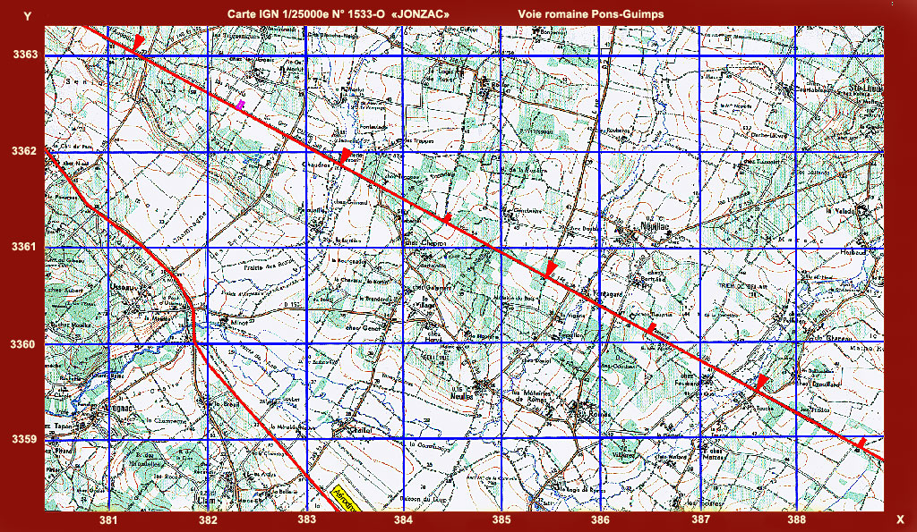
The ancient way Pons-Guimps, St Martial, Aubeterre s/Dronne, tested by the methods of topographic remanence, reveal, at least in its rectilinear part Pons-Guimps, thirteen points of coincidence aligned according to perfect metric of 2416 meters. The probable initial position of the terminal of Chadenac, revealedby this method, is the point or the way cuts the brook of Le Mortier. It was discovered with approximately 1500meters from there, with flight of bird, the right of the way, the locality " La Chapelle" (cemetery mérovingien, excavated since).
| Card IGN 1/25 000e | Nom/désignation | X Lambert | Y Lambert |
| 1532-E | D 142 | 378500 | 2065440 (II) |
| 1533-E |
Voies
| 380200 | 3363620 (III) |
| 1533-E | Audouin | 381250 | 3363050 |
| 1533-E | Missing index | 382320 | 3362450 |
| 1533-E |
Mortier
| 381250 | 3361850 |
| 1533-E |
Chez Chapron
| 384400 | 3361275 |
| 1533-E | D 148 | 385450 | 3360690 |
| 1533-E |
Bois des Ajoncs
| 386540 | 3360080 |
| 1533-E | D 250 E2 | 387570 | 3359510 |
| 1533-E |
Les Billonnelles | 388630 | 3358925 |
| 1633-O |
La Pouyade | 389600 | 3358360 |
| 1633-O |
Les Branges
| 390620 | 3357800 |
| 1633-O |
La Font
| 394015 | 3356405 |
| 1633-O |
LePérat
| 395145 | 3356020 |
Other method of measurement length of the league :
When a way presents a great rectilinear part (it is the case of this way at the time of the crossing ofcard IGN 1533-E " Jonzac " or we belong to the remarkable topographic points to each 1/2 mile), it is enough to calculate the distance between extreme points and to divide it by the number of leagues.

Fig 15. Roman way Pons-Guimps, between Marignac and Sainte-Lheurine.
|
|
|
|